What I did on my summerMemorial Day Vacation

Disgusted with my out-of-shape state, lately I’ve been trying to spend time in the Big Room more often. I hate exercise-for-the-sake-of-exercise, but I do enjoy getting out and exploring, so muscle-powered travel around the Big Room is a convenient fitness-improving activity. As we have a spiffy wooden kayak I’ve named “The Ascospore“, and live near a decent-sized body of water that I’ve not sufficiently explored, getting out and doing some lake-spanking was a Moral Imperative.

(If you’re reading this entry via RSS, you probably don’t see the map and the associated photographs below, so please follow the link to view this post directly…)

Also, here’s a direct link to the KML file if you want to pull it into a full Google Earth session for browsing…

Only 9¼ miles, but that’s not too bad. The Memorial-Day motorboaters were making a lot of waves, which were kind of fun but made the paddling somewhat slower and more strenuous than it would otherwise have been.

Oh, yeah, and I discovered that digiKam not only has a set of geolocation functions, but even has a plugin that will generate a KML file out of the track and photos, which I used for this map – I just had to edit the descriptions and picture titles and such to add whatever else I wanted. Very nice. On the other hand now I’m reminded that I need a better digital camera…

Of course, nerd that I am, I spent a good portion of the trip looking at the greenish water and cursing once again my lack of a decent microscope. There must be a huge variety of tiny little things in there. It also occurs to me that I know very little about diatoms, for example. But now my mind is obviously wandering due to sleep deprivation and it’s time for bed. Hopefully the embedded map works right. Let me know if not.

Linux on the EeePC 901 a fortnight later…

'Penguin Powered!' stickersLife’s been a couple of weeks of hectic mess, but we’re still here. I’ve also now had “Bit” for about a fortnight. I still love it.

I did run into an odd problem, though. People occasionally report that they have trouble getting their Linux boxen to connect to encrypted networks. Even when “regular” encrypted networks work, sometimes people say they have trouble connecting to the hardcore “Enterprise”-grade networks running certain varieties of the WPA2 encyrption, as is in use for example on campus where I work.

I, however, had no trouble with these. I’ve got WICD installed, and I can just pick the network I want out of the list that pops up, enter the relevant password/”key” information for whatever encrypted network I want, and hit “connect”. No problems at all. It’s the plain, unencrypted “public” networks I had trouble with.

Apparently, the wireless network card in the EeePC 901 is based on the relatively new Ralink RT2860 chipset. Ralink provides native Linux drivers, which so far work impressively well. The one problem they have turns out to be that the drivers don’t respond to the old-school “iwconfig” program that everything expects to use to tell a wireless card to connect to a public wireless network. Since WICD expects to be able to do this, connections to unencrypted networks were failing silently. Hopefully this single irritating quirk in the drivers will be corrected – or perhaps a workaround implemented in WICD.

Meanwhile, there’s a workaround – you can use another tool that comes in the same package as iwconfig called “iwpriv” to set the network information. I whipped up a quick script that I can feed the name of the network and channel I want to connect to and it sets the card appropriately. THEN when I push the “connect” button in WICD, it works.

I was glad for the wireless networking performance today when some jerk set off the fire alarm in the building where I work (for about the 4th or 5th time in the last 6 months or so) and we all had to shuffle outside and sit around at a “safe” distance from the building while we waited for someone to decide there wasn’t really a fire and let us back in. I was able to stay on the wireless network from a fair distance outside the walls, and was thus spared the tragic fate of losing my connection to the InterTubes and having to interact with the real world…

If you have a use for it, the pathetically simple little script I use is:
#!/bin/sh
#call with: raconnect.sh (ssid) (channel)
iwpriv ra0 set EncrypType=NONE
iwpriv ra0 set AuthType=WEPAUTO
iwpriv ra0 set SSID=$1
iwpriv ra0 set Channel=$2

The way I use it is I pop up WICD and find the network I want to connect to. Let’s say it’s called “PublicNet” on channel 1. I tell the computer to run “raconnect.sh PublicNet 1”. Then I can push the connect button in WICD and it seems to work fine. (It may be that you can leave out the Channel line, I haven’t tried that yet.)

That’s really the only problem I’ve run into so far. Otherwise, everything just plain works that I’ve tested at this point. I even loaded, geotagged, cleaned up, and posted the most recent few photos I put on Panoramio entirely on this little machine. I was right, incidentally – fixing the “GigantoFonts” problem solved the problem of Google Earth popping up too big. The Linux version runs just fine now on my EeePC 901.

I should probably post something that isn’t me blathering about my cool new toytool, though. Anybody want to know anything?

Interactive Photo-Map: Oil and Rocks and Squiggly Things

No audio narration, but there is a spiffy map that you can scroll around in, complete with icons you can click on to see the photos and some text to go with them. Who could ask for anything more? Besides audio narration in my mellifluous voice, that is.

Since the embedded “Google Maps” image doesn’t seem to appear in the RSS feeds, I’m adding it after the “Continue Reading” link below – please do so and let me know how it works. As usual, suggestions are welcome – I’d like to do more of this kind of thing when I have time to travel. (Suggestions for future locations or themes are welcome as well).

Continue reading Interactive Photo-Map: Oil and Rocks and Squiggly Things

JelloLlamaJalama Beach Teaser Post

Okay, I finally worked out what was screwing up my geolocation (the new dates for Daylight Losings Time) and had a chance to sit down for a while today to work on cleaning up my photos for upload. I really need to get a new digital camera that handles low-light conditions much better. I did manage to get a photo of the Majestic Natural Glory of the Los Angeles river from the train, though, despite the tinted windows. Take a look:

Ain’t it pretty? They say the waters of the Los Angeles river are so pristine that they taste like (Miller|Coors|Bud|Insert-Your-Least-Favorite-Beer-Here) Lite®!

Here’s a question for everyone who reads this: I’m planning to turn the Jalama Beach photos and track into an interactive map post (Hopefully tomorrow [Sunday, April 5th]). Anybody want audio narration to go with it? Also, is anyone but me playing with the Mozilla Firefox 3.1(/3.5) beta, or the latest experimental Opera or Safari browsers, i.e. browsers that support the HTML5 <audio> tag?

And, since I titled this post “Jalama Beach teaser”, and while I’m talking about Pristine Natural Beauty, here’s a sample:

A natural Tar Seep on Jalama Beach

Woe is me (some more)

We’re back from our all too short stress-management vacate-shun. I’m chronically underslept (indeed, I ought to be in bed right now) and now I think I’m coming down with a generic Obnoxious Respiratory Ailment for the third time in as many months, which is extremely unusual for me, and which I definitely Do Not Want. Also, it turns out that as usual, Motorola cellphones are crippled. My Razr V3 apparently doesn’t allow applications to access the camera, so there’s no way for me to cram a functional datamatrix barcode decoder onto it. And the built-in wireless networking in Igor (my venerable 3½-year-old laptop) appears to have died…

I need a new cellphone. And a microscope. And a “netbook”. And a digital camera that handles low-light conditions and close-ups better. (And a pony?…) Still, things aren’t all bad, for all my whining.

A DataMatrix barcode painted in watercolors...I did manage to get some interesting pictures on the trip, at least, along with GPS tracks for geolocation purposes. Also, wine jelly and interesting spices from generous family members we were visiting, and even some avocado honey from a little roadside produce stand on the way back to the train station for the trip back.

I’m going to bed now. Hopefully after work tomorrow or this weekend I’ll be putting up another post (and start posting more often again). Anybody want to see pictures of oil and rocks from JelloLlamaJalama Beach, or the majestic Los Angeles River?

Exhaustipated, but I’m home

I had to forgo the pleasures of lounging in the hotsprings, due to the excess of time it took to load up Flagella for the trip back and finish running errands. I had to get out of Idaho while the getting was good, as another storm was on the way. Still, the return trip wasn’t a total loss:

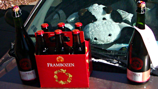
FloppyCow gazes from inside Flagella (my car) at the beer I just picked up at New Belgium Brewing Company - La Folie and Frambozen
I managed to score a couple of bottles of La Folie and a six-pack of Frambozen. FloppyCow is jealous. These brews may make a decent relaxative with which to treat my exhaustipation.

I learned a few things playing with my prototype “Where Was I? application for Asterisk. For one thing, I need a longer greeting message, so that my asterisk box will still be listening when my cellphone finally obeys me mashing on its keypad and sends the tones. For another, Suddenlink may be screwing me over on my outgoing data (I’m supposed to be getting 384k outgoing, which ought to be plenty of bandwidth, but strangely enough from outside my VOIP packets are getting completely screwed up. I need to research this to see if it’s really them.) In any case, I had fun playing with it, and now have a better idea of how to (re-)design it for regular use.

Meanwhile, though, now that the car is finally unloaded again it’s time to rest and try to remember everything else I needed/wanted to get done during the holiday break.

I WANT MY FRIGGIN’ ELECTRICITY!

99%(!) of Entergy Texas’ customers are apparently without power right now. I wish they’d actually put some effort into preparing the lines for severe weather and streamlining the repairs, instead of letting the whole thing fall apart and then getting the state legislature to approve yet another “Hurricane Cost Recovery Charge” to be added to everyone’s bills to pay to return everything to the same “ready to fail at the next batch of severe weather” state…How do I get in on this deal?

Being without air conditioning in southeast Texas this time of year is almost intolerable. If they manage to restore service quickly despite my cynicism, I’ll probably feel a lot less cranky…

On the upside, it appears there should be some scenic carnage visible out on the lake if I manage to get some time to get out and paddle around a while between bouts of moving bits of broken tree around the yard. Here’s a sample shot taken from the shore of Lake Conroe earlier today:

Continue reading I WANT MY FRIGGIN’ ELECTRICITY!

Aqua-pedestrianism and Ice Cream Yeast

A teaser image from the interactive map below...Today’s batch of blog-based Stir-Fried Random includes another interactive map of a lake-spanking expedition, a very brief musing on search engines, and a return to “intentional food microbiology” discussion. To preview: you can get pizza without ever getting out of the water on Lake Conroe, “spanking” is amusingly popular for search engines, and no, there is not normally any yeast in ice cream, but perhaps there could be. Read on, please…

Continue reading Aqua-pedestrianism and Ice Cream Yeast

Lake-spanking map and pictures

Lake Conroe has been persistently naughty. Since nobody else seemed to be taking responsibility for its misbehavior, we took matters into our own hands yesterday and gave it a good spanking. I paddled it until I got blisters.

I think this will need to be done much more often, since I don’t think the lake has learned its lesson yet. On the other hand, I learned a few – interactive photo-map and details below…

Continue reading Lake-spanking map and pictures

Another cheatin’ “Open Thread” and random stuff

No single topics to dominate a post today. I’m in a hurry (as usual lately) and have very little time. Tomorrow morning I’m back on the 1600-mile route back to Southeast Texas, hopefully to sign the closing paperwork on the house we’re trying to buy.

My Mountain Dew® Wine appears to be still sitting there after several hours. Either the benzoic acid is still inhibiting the fermentation (in which case it’ll go REALLY slowly) or the yeast is just in shock or something. We’ll see how it looks in the morning. I’ll leave it for a week or so anyway to see how it does. Meanwhile I’ll refrigerate the other batch of yeast culture until I get back. If I have to develop my own strain of “Mountain Dew Yeast” I will, dagnabbit!

I did get a chance to go for a quick walk in the Big Room on the way back from some errands yesterday, so it gives me an excuse to play with the wordpress map plugin again (RSS feed readers: the map doesn’t get inserted there. Please check out the interactive map at the blog’s website here.) Comments on the map (or anything else, really – I DID say “Open Thread” after all) are encouraged – what do you think? I’d like to do some audio content for points on a map at some point, too. Maybe some video.

Lava Rock Walk [height=560;width=560]

If anyone’s bored enough to want to see how I get from Southeast Idaho to Southeast Texas, I can post a map of that tomorrow, too…